3D mapping of your sites, immersive virtual tours, BIM modeling and digital twins
Learn moreABOUT
Keovia Solutions supports you to value your built environment thanks to digitization and modeling solutions.
Funded in 2019, Keovia Solutions relies on the international experience for more than two decades of its team in construction and digital technologies. We are convinced that the now mature digitization solutions and capabilities to use digital data will accelerate the opportunities to value existing buildings and their usage.
At each step of your project, we implement the best adapted solution for your needs. Our teams come to 3D map your sites with terrestrial and aerial technologies. The data, generally 360 pictures and point clouds are prepared according to your expectations.
Based on the 3D scans, the pre-existing documentation and monitoring data, the digital twins of your buildings are created or updated as immersive virtual visits, BIM models or numerical models.
Our experts and partners support you in the technical analysis and the development of dedicated solutions, whether for the management, analysis or use of your installations.
Immersive Virtual Visits
From anywhere and at anytime: Promotion and pre-visit for real-estate or commercial, facilitate the remote access or the preparation of visits of your reference installations. Remote operations management thanks to realistic visualization and remote collaboration, as well as as is technical documentation or preparation of safe and efficient on-site intervention.
A few advantages :
The virtual visits service can be declined at different levels:
- Project evaluation
- On-site terrestrial and/or aerial 3D scans
360 photos, point clouds, aerial 4K videos - Web access to the virtual visit
- Virtual visit enriched according to your needs (content, dedicated plugins)
- Reknown platforms integration: NavVis IVION, Matterport, Prevu3D, Google StreetView
Immersive Virtual Visits
From anywhere and at anytime: Promotion and pre-visit for real-estate or commercial, facilitate the remote access or the preparation of visits of your reference installations. Remote operations management thanks to realistic visualization and remote collaboration, as well as as is technical documentation or preparation of safe and efficient on-site intervention.
A few advantages :
The virtual visits service can be declined at different levels:
- Project evaluation
- On-site terrestrial and/or aerial 3D scans
- 360 photos, point clouds, aerial 4K videos
- Web access to the virtual visit
- Virtual visit enriched according to your needs (content, dedicated plugins)
- Reknown platforms integration: NavVis IVION, Matterport, Prevu3D, Google StreetView
3D model and Scan-to-BIM
3D model and Scan-to-BIM
Development of the as-built digital models or BIM models according to the required level of details (LOD) to feed the installations documentation or digital twins. Preparation of the models at the relevant standard (interoperability) for direct exploitation or expert analyses.
- BIM Management Plan preparation
- Coordination support
- Model specification support
- On-site 3D scan
- As-built modeling (BIM, meshing) based on the point cloud or drawings, under the required standard
Development and Studies
Real-time integration within digital twins of monitored information (IoT) and delivered through dashboards adapted to the usage.
Advanced technical studies, development of tools for specific analyses or coordination of R&D programs.
- Specification definition support
- Digital twin extension with dedicated users interfaces and real-time monitoring data integration
- Scientific and technical expertise
- R&D programs coordination
Ressources

NavVis VLX
The NavVis VLX scanner offers high efficiency digitization opportunities (Up to 10 time faster than terrestrial laser scanners). It is using LiDAR and SLAM technologies as well as 360° views. The efficiency and the technology allow 3D mapping large surfaces sites, indoor or outdoor.
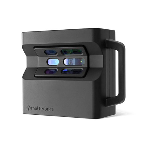
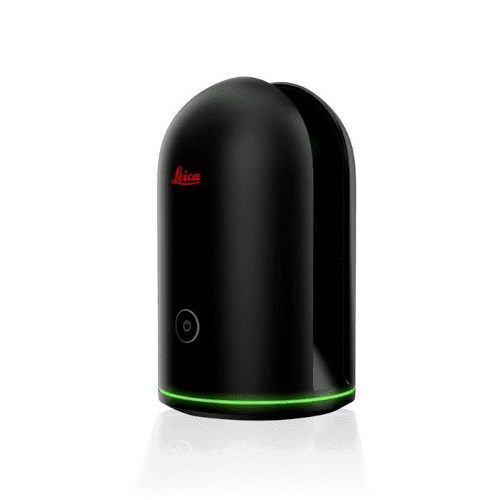
Matterport PRO2 et Leica BLK360
The terrestrial scanners Matterport PRO2 and Leica BLK360 allows to realize both high quality 360 photos and 3D scans of buildings with adapted accuracy (0.1 to 1%) coupling LiDar, photogrammetry and thermography.
![]()
![]()
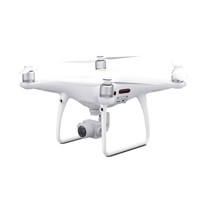
Le Phantom 4 Pro v2.0
The Phantom 4 Pro v2.0 is a reference professional drone, equipped with 1’’ sensor to realize high quality aerial views (photos, ortho-mosaics or point clouds by photogrammetry, 4K videos)
We use the services of the virtual visits’ platforms from the market references Matterport and NavVis (Indoor Viewer)
Ressources
NavVis VLX
The NavVis VLX scanner offers high efficiency digitization opportunities (Up to 10 time faster than terrestrial laser scanners). It is using LiDAR and SLAM technologies as well as 360° views. The efficiency and the technology allow 3D mapping large surfaces sites, indoor or outdoor.
The terrestrial scanners Matterport PRO2 and Leica BLK360 allows to realize both high quality 360 photos and 3D scans of buildings with adapted accuracy (0.1 to 1%) coupling LiDar, photogrammetry and thermography.
![]()
![]()
Le Phantom 4 Pro v2.0
The Phantom 4 Pro v2.0 is a reference professional drone, equipped with 1’’ sensor to realize high quality aerial views (photos, ortho-mosaics or point clouds by photogrammetry, 4K videos)
We use the services of the virtual visits’ platforms from the market references Matterport and NavVis (Indoor Viewer)
You have a project or a question?
Do not hesitate to communicate with us and we will be pleased to support.
Email: contact@keoviasolutions.com
Phone: +1.514.623.3242
Address: 2020 Trans Canada Highway #107, Dorval, QC, H9P 2N4, Canada